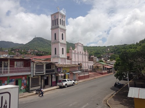
A Mountain Wearing a Cloud
Look southeast from the streets of Matagalpa on a cool morning and you will see it: a green ridge with a ribbon of mist caught on its shoulders. That is Cerro Apante, and the cloud is not weather passing through. It is the reason the mountain exists as it does.
Roughly 3 km from the city centre, the Cerro Apante Natural Reserve climbs from about 900 metres to just over 1,440 metres, and somewhere around 1,300 metres the air changes. The temperature drops, the light turns soft, moss and ferns cover the branches, and the forest begins to drip. You have walked out of a Central American coffee town and into a cloud forest.
Almost nobody expects this. Cloud forests are rare, fragile, and usually imagined somewhere far away, in Costa Rica or the Andes. Matagalpa has one within walking distance of its cathedral, and it is doing something far more practical than looking beautiful: it is supplying the city with water.
How a Mountain Makes Its Own Climate
The region's cool temperatures are a gift of altitude. Around Matagalpa and Jinotega the mountains run from about 800 to 1,640 metres, and the temperature sits between 18 and 24 °C most of the year, which is why the area is famous for its "eternal spring."
The rain follows a simple logic. Moist air blows in from the Caribbean, meets the high mountains around Matagalpa and is forced upward. As it rises it cools, the water condenses, and the mountain wrings it out as rain and mist. That is orographic rainfall, and it is why this region is crossed by so many streams.
On Apante the numbers are precise. Average rainfall runs from about 1,350 mm at the foot of the mountain to about 1,600 mm at the top, falling over six to seven months from May to November. Average air temperature is about 21 °C at 900 metres and only about 16 °C at 1,400 metres, with a gap of only around 2 °C between the warmest and coolest months. From about 1,300 metres, according to the reserve's management plan, the forest is bathed by regular streams of mist.
This mist matters as much as the rain. Trees, mosses, ferns and orchids in a cloud forest drink directly from the fog, drawing moisture out of the air itself. In the dry months, when the lowlands brown, the mountain keeps dripping.
A Forest Where North Meets South
The most surprising thing about Apante's vegetation is that it holds trees from two worlds.
The reserve's plan records liquidámbar (sweetgum, Liquidambar styraciflua) and nogal (Juglans olanchana), valuable species from North America that reach their southern limit in Nicaragua. There are several species of oak, and Pinus oocarpa, the Central American pine. Beside them stand giant tree ferns that locals call "cola de mono" (monkey's tail), which look like they belong in a dinosaur film.
Near Apante and the neighbouring Peñas Blancas there is a grove of sweetgum with individual trees over 40 metres tall and more than 50 inches (about 1.3 m) across, valued as a seed stand of high genetic importance for conserving tropical sweetgums. In a mountain that has seen centuries of farming, a stand like that is a living library.
The branches are loaded with epiphytes, plants that live on other plants: ferns, mosses, climbers, "old man's beard" and orchids (eight orchid species were recorded in the early survey). The forest is also a medicine cabinet. Locals have used cuculmeca, sangredrago, Peru balsam, zarzaparrilla and "suelda con suelda" for generations.
A word of honesty belongs here. The 2000 survey that produced these numbers found only 75 plant species, and the plan itself admits that research on the reserve is scarce, so the real list is certainly longer. The plan also notes that some trees that now look wild, such as cedro real, macuelizo and nogal, were introduced by the farm owners over time. This is a forest shaped by people as well as by nature, and that is part of its story.
The Animals
The mammals recorded in the reserve read like a roll call of the Central American forest: spider monkeys, mantled howler monkeys, white-faced capuchins, ocelots, pacas, agoutis, white-nosed coatis, red brocket deer and collared peccaries. Among the smaller residents is the Matagalpa pocket gopher, a burrower named for the region. Several of these species are threatened, and the spider monkey is among the animals the plan singles out.
The birds recorded include the great curassow, a big, handsome ground-dwelling bird, and the highland guan, known locally as the chachalaca. Both are forest birds that vanish when the trees go.
One note for birders: some online listings promise quetzals in Apante. The reserve's own management plan says plainly that there are no quetzals in the area. The resplendent quetzal is a bird of other cloud forests, so keep your expectations honest and enjoy what is actually there.
Wildlife here is shy and the mountain is close to a growing city, so most walkers will hear more than they see: a troop of monkeys moving through the canopy, a guan calling in the mist, something rustling in the leaf litter. Early morning gives the best chance.
The Forest That Fills the Taps
Here the cloud forest stops being a pretty idea and becomes infrastructure.
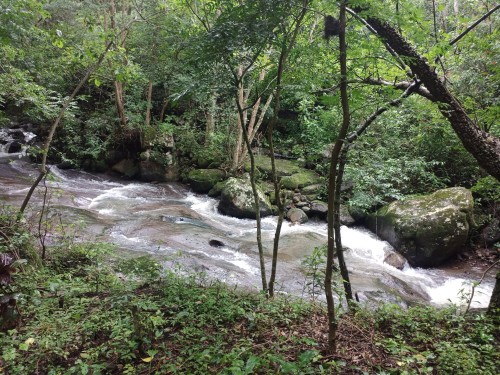
The reserve is part of the Río Grande de Matagalpa watershed, which eventually reaches the Caribbean, and its streams are the main reason the mountain was protected. When the management plan was written, roughly 825 homes and about 5,000 people depended on the reserve's water, most of them in the city. The Yaguare river, born high in the reserve, is dammed at La Providencia farm and supplies eight Matagalpa neighbourhoods, around 663 homes. A community water committee ran that system, and had for more than twenty years.
The logic is simple. A healthy forest catches mist and rain, slows it down, soaks it into the soil and releases it gradually all year. Strip the trees and the same rain runs straight off the slope in a flood and disappears. The plan estimates that the 633 hectares of forest alone can infiltrate hundreds of thousands of cubic metres of water a year.
That is also why the mountain's slopes matter beyond tourism. During Hurricane Mitch in 1998, the Yaguare stream, which drops steeply and then runs through the city, showed how dangerous a torrent from a damaged slope can be. The forest is a water tank and a brake at the same time.
A Reserve Made of Coffee Farms
Apante is unusual for another reason: it is almost entirely private land. The reserve covers about 1,960 hectares (the figure in the 2018 plan is 1,962 ha; the earlier plan counted 1,989 ha) and was divided among 16 private properties when the first plan was drawn up, mostly large and medium coffee farms. There is practically no state-owned land inside it, apart from the river beds.
When the first plan was written, forest covered about 31% of the area, shade-grown coffee 44%, pasture 18% and regrowing scrubland 7%. Coffee is the economic engine of the mountain, and it is not necessarily the enemy: shade coffee grown under tall trees keeps a canopy over the slopes. The plan makes the point directly, saying that the real problem is not coffee itself but monoculture and polluting production methods.
So the reserve works in an unusual way. It is not a fenced wilderness. It is a working landscape where farmers, the municipality and the environment ministry share responsibility for keeping the forest and the water alive.
How It Is Protected
Cerro Apante was declared a protected area by presidential decree in 1991. The first management plan was approved in 2002, developed with Nordic and Danish support, and a revised plan was approved by the environment ministry (MARENA) in July 2018. Today it divides the land into zones: about 470 hectares of water-source protection, about 566 hectares of recovery-for-conservation, about 926 hectares of multiple use, and a much larger buffer zone of about 1,757 hectares around it.
The rules are specific. According to the plan, inside the reserve it is forbidden to:
- hunt, fish or capture threatened wildlife, or remove plants and animals without a permit;
- replace natural forest with plantations or pasture;
- burn, apart from controlled agricultural burns on established fields;
- use toxic pesticides, explosives or poisons;
- dump rubbish or pollutants, including raw coffee wastewater and pulp, into the streams;
- introduce exotic species or genetically modified organisms;
- open new quarries or build on slopes of 40 degrees or more, or close to rivers.
The 2002 plan added further rules: the natural mountain forest that shades coffee may not be cut to plant something else, there is a protective strip of about 25 metres on each side of streams, and public roads in the reserve carry a 20 km/h speed limit. It also called for a team of professional rangers backed by volunteer ones, and for environmental education in local schools.
The main threats were identified plainly: uncontrolled fire (sometimes started by people trying to trap wild animals), pollution of water from coffee processing, and deforestation. In the early 2000s the plan counted around 4,000 subsistence firewood cutters and 500 commercial ones in the area, since wood remained the main cooking fuel for many homes in Matagalpa.
That last problem has practical answers. A UNDP-supported project in communities near Apante worked with 342 families on fuel-efficient cookstoves and reforestation, planting more than 6,000 seedlings across 4.3 hectares of degraded forest, with priority on river areas. It is small, but it shows the method: protect the forest by solving the problem that sends people into it.
Nature does not read management plans, of course. The plan itself describes the ecosystem as endangered and degraded, and good rules on paper depend on funding, enforcement and the goodwill of farmers. The forest holds on, but it is not safe by default.
The Cross on the Peak
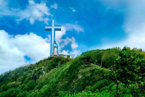
On top of Cerro Apante stands one of the most striking landmarks in northern Nicaragua: the Cruz de la Paz, the Cross of Peace, on what the Church calls the Montaña de la Paz (Mountain of Peace).
The cross is 33 metres tall, about five metres shorter than Rio de Janeiro's Christ the Redeemer, and beside it stands a 12-metre image of the Virgin of Guadalupe. Local press has called it the tallest religious monument in Nicaragua. It was inaugurated in November 2014 during the celebrations for the 90th anniversary of the Diocese of Matagalpa, and it can be seen from the cathedral in the city below.
Every year, on the Sunday nearest to 3 May, thousands of pilgrims climb to it. They begin at the San Pedro Apóstol Cathedral and walk a Way of the Cross of 18 stations over about four kilometres, and in 2017 the Church expected more than 15,000 people. For a day the mountain becomes a long line of people moving upward through the forest.
Even if you are not religious, the combination is remarkable. A giant cross and a giant Virgin, set on a ridge of mist and trees that quietly provides the water for the town they overlook. On a clear day the view runs over the whole Matagalpa valley, and on a misty one the cross seems to float.
Visiting Apante
The reserve is easy to reach: the roads from Matagalpa lead into it from several sides, and a typical hike to the top takes around two hours. The management plan notes that the antenna hill, Apante Grande, is under an hour's walk from the city, and the roads there make good scenic walks or bike rides. Hikers also follow loop trails of around 8 km. A local guide helps with the route and with spotting plants and wildlife.
A few practical points:
- Respect private land. Most of the reserve consists of private farms, and the plan requires visitors to have the owner's permission before entering one. Ask before leaving the public paths.
- Take nothing. Removing plants, animals or microorganisms is prohibited.
- Pick the season. The dry months, roughly November to April, give the clearest views. The rainy season, May to November, brings the lushest, mistiest forest and slippery trails.
- Bring layers. It is noticeably cooler at the top than in town, and the mist can come in fast.
- Avoid the pilgrimage Sunday unless you want the crowds, and go in daylight.
For more cloud forest, the Selva Negra reserve on the road to Jinotega has 14 hiking trails and a very different, lodge-based experience, and the Cerro Arenal reserve nearby is another protected cloud forest, with rain falling about eight months a year.
A Landmark Worth Keeping
It is easy to treat Apante as a pleasant hike and a good photograph. It is more than that, and it asks something of us.
Every city has a hidden dependency: something far away or high up that keeps it alive without being noticed. For Matagalpa it is this mountain. The mist that collects on those branches ends up in kitchens and taps a few kilometres downhill. The cloud forest is not decoration. It is the city's lungs and its reservoir at the same time.
That is why protecting it is not only about monkeys and orchids, although it is about them too. It is about whether a growing town, a coffee economy and a fragile forest can share one mountain without destroying each other. For now they do, imperfectly, through rules, farms, schools and stoves. It is a quiet success that deserves to be known, and a good reason to walk up and look at it properly.
For the easiest access to the trail, I recommend staying at this Airbnb, which is just a 22‑minute walk from the entrance to Sendero Turístico La Cruz de Apante: Casa Colibri
Related articles:
Bus Schedules Matagalpa to Managua, Jinotega, Estelí, León
Managua Bus Guide: Getting Around the City and to Other Towns
Hiking La Cruz de Apante: Cloud Forest Trail Above Matagalpa